




The Layers Are Real: What the Grand Canyon Actually Shows Us
Part 1 of our series examining where biblical creation and conventional geology agree on the evidence, where the interpretation begins to differ, and why.
Stand at almost any overlook along the South Rim of Grand Canyon and one thing is immediately obvious: the canyon is layered. Broad bands of limestone, sandstone, shale, and other rock types form cliffs and slopes that can be traced for miles across the landscape. Some are light and massive. Others are thin, dark, or deeply recessed. Together they form one of the clearest and most spectacular displays of sedimentary layering anywhere on earth.
Biblical creation does not require us to deny those layers. We can recognize that different formations represent different depositional conditions, that some units can be correlated across large regions, and that the contacts between them record real changes in what was happening when those sediments were deposited.
We see the layers too.
The question is not whether the layers are there. The question is what history best explains them.
The Layers Are Real
Grand Canyon gives us an extraordinary cross-section through thousands of feet of rock. From the Kaibab Formation at the rim to the Tapeats Sandstone near the bottom of the main sedimentary sequence, the rocks are not one uniform mass. They differ in composition, grain size, sedimentary structures, fossil content, thickness, color, and resistance to erosion.
Those differences matter. They tell us that conditions changed during deposition.
Sand was transported and deposited under one set of conditions. Mud accumulated under another. Carbonate sediments formed under still others. Currents changed. Water depths changed. Sediment sources changed. The chemistry of the water changed. Biological material was buried in different places and under different circumstances. None of that is controversial simply because we approach earth history from a biblical worldview.
The disagreement begins when those observations are placed into a particular timeline.
Within conventional geology, many large sedimentary sequences are explained through repeated marine transgressions and regressions, meaning that shallow seas advanced across portions of the continents and later retreated, with different layers accumulating during different episodes over immense spans of time. In that framework, the layers exposed at Grand Canyon represent only a small portion of a history extending through hundreds of millions of years.
We agree that water moved across the continents. We agree that depositional environments shifted. We agree that the same location did not experience identical conditions throughout the entire sequence.
What we do not agree with is that those changes necessarily require millions of years between them.
The Scale of the Deposits Matters
One of the things that becomes easy to miss when looking across Grand Canyon is just how large these sedimentary systems are. The canyon gives us a spectacular window into them, but the formations do not stop at the canyon walls.
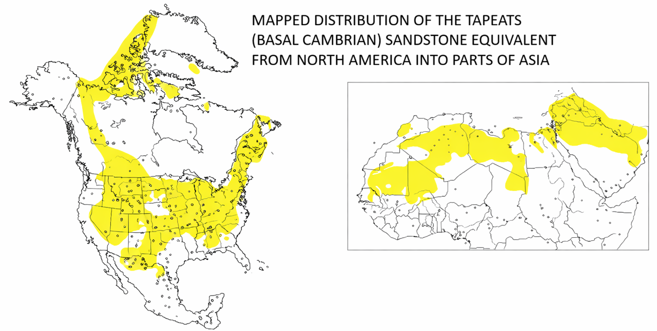
The Tapeats Sandstone is a good example. The name Tapeats is used locally at Grand Canyon, but equivalent basal sandstones can be traced or correlated across enormous portions of North America. The same is true, in different ways, for other major sedimentary packages. We are not looking at deposits confined to one valley, one river, or even one state.
That continental scale should shape the questions we ask.
A deposit spread across a large portion of a continent requires a process capable of moving and depositing enormous quantities of sediment over an enormous area. From a Flood perspective, that is not an unexpected feature of the rock record. A global catastrophe involving rising waters, powerful currents, tectonic activity, erosion, sediment transport, and progressive inundation would operate on a scale far beyond the processes we normally watch from year to year.
This does not mean that every large rock unit automatically proves the Flood. Size alone is not the argument. The point is that continent-scale deposits are entirely at home within a catastrophic model and should not automatically be interpreted as the quiet accumulation of sediment over vast ages.
What Happened Between the Layers?
Another important question concerns the contacts between formations. If long spans of time separate two rock units, what should we expect to find at the surface between them?
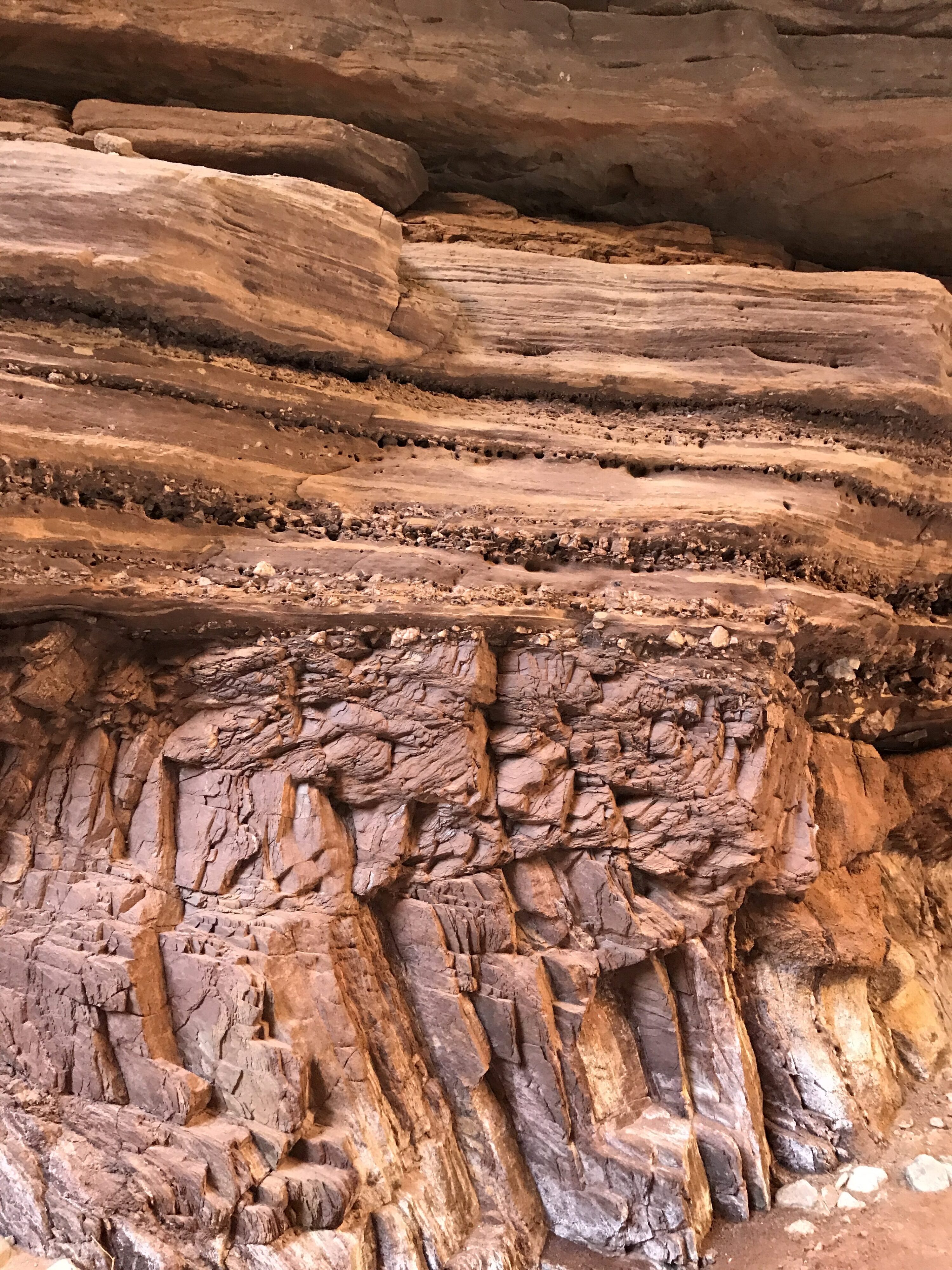
That answer will vary with environment, climate, rock type, and exposure, so we should be cautious about making simplistic claims. But many contacts between major sedimentary units are remarkably broad and comparatively flat. At Grand Canyon, one formation can often be followed directly into the next across a tremendous distance with relatively little evidence of the mature landscapes, deeply developed soils, extensive drainage systems, or profound weathering that we might intuitively expect if the surface had remained exposed for an immense span of time.
That does not mean there was never erosion between layers. There plainly was. Grand Canyon contains major erosional surfaces, including the Great Unconformity itself. The issue is not whether erosion occurred, but how much time that erosion requires.
During a large and continuing catastrophe, sediment can be deposited, eroded, transported again, and then buried beneath another deposit as conditions change. A surface does not need to sit exposed for millions of years simply because some of the material beneath it was removed before the next layer arrived.
In other words, an erosional boundary tells us that erosion happened. It does not come with a clock attached.
A Flood Would Produce Layers
Sometimes the Flood model is pictured as though all sediment everywhere was dumped at once into one chaotic mixture. If that were our model, the organized layering visible at Grand Canyon really would be difficult to explain.
But that is not the model.
The Genesis Flood describes an event unfolding over many months. A global catastrophe of that magnitude would involve changing water depths, changing current directions, different sediment sources, tectonic movement, erosion of existing surfaces, burial of ecological regions, and the continual redistribution of sediment. As conditions changed, the kinds of material being transported and the places where that material settled would change as well.
From a biblical Flood perspective, global tidal effects would also have been operating on a dramatically altered world. With the continents increasingly inundated and fewer land barriers interrupting the movement of water, powerful tidal currents could repeatedly sweep across broad regions, eroding landscapes, carrying sediment great distances, and redepositing that material in thick packages. Long-distance sediment transport is not merely hypothetical. Detrital zircon studies indicate that a substantial portion of the sand in the Navajo Sandstone, exposed just north of Grand Canyon across the Colorado Plateau, ultimately came from the Appalachian region and was transported westward across much of the continent before final deposition. Within a Flood framework, that kind of transcontinental sediment movement is consistent with the scale of currents expected during a global catastrophe.
Cross-bedding provides another important clue. Cross-bedding and other current-generated sedimentary structures occur throughout much of the Grand Canyon’s sedimentary sequence, from the Tapeats and Bright Angel near the bottom to the Redwall, Supai, Hermit, Coconino, Toroweap, and even portions of the Kaibab near the rim. These structures record the migration of bedforms under directional flow. In water-laid deposits, they preserve evidence of strong horizontal currents moving and organizing sediment across the landscape. Cross-bedding does not by itself tell us how long deposition took, but it does show that large volumes of sediment were being actively transported by moving currents.
Moving water is remarkably effective at sorting material. Differences in grain size, density, shape, settling rate, current velocity, and water chemistry can all contribute to distinct layers. Sand can be separated from finer mud. Carbonate-rich sediment can accumulate apart from siliciclastic material. Strong currents can erode one surface and spread new sediment across it. None of this requires sedimentation to be slow.

We see this even on much smaller scales today. Floods, storms, turbidity currents, volcanic events, and underwater sediment flows can create multiple distinct beds in a short amount of time. Grand Canyon represents something vastly larger, but the basic principle remains important: layering is a record of changing conditions, not a stopwatch.
The fact that sandstone lies above shale, or limestone above sandstone, tells us that the depositional environment changed. It does not, by itself, tell us how many years passed while that change occurred.
Same Layers, Different History
This is where the conversation becomes more useful than the caricature. Biblical creation and conventional geology are looking at the same canyon. We can stand at the same overlook, point to the same formations, identify the same sedimentary structures, examine the same contacts, and agree that real geological events produced what we see.
The difference comes when we reconstruct the history behind those observations.
We see a thick sequence of sedimentary layers. We see formations that extend across enormous geographic areas. We see evidence of changing depositional conditions and major episodes of erosion. We also see many boundaries that do not appear to preserve the kind of prolonged landscape development we might expect if vast ages separated every major deposit.
From a biblical creation perspective, much of that evidence fits naturally within the framework of the global Flood described in Genesis. The Flood was not a single moment of deposition, but a dynamic sequence of erosion, transport, burial, tectonic activity, changing currents, and changing environments operating on a continental and global scale.
That does not answer every geological question, nor should we pretend that it does. Good geology means looking carefully at the rocks, asking what physical processes could have produced them, and being willing to distinguish what we actually observe from the historical interpretation we place upon those observations.
At Grand Canyon, the layers are real.
We simply do not believe that every change between them requires another chapter of deep time.
In the next article in this series, we will look at another point of common ground that sometimes surprises people: terms such as Cambrian, Mississippian, Permian, and Precambrian can still be useful within a biblical creation framework. The names are useful. The ages attached to them are where the disagreement begins.

Three Rock-Solid Evidences for a Global Flood
For a closer look at the evidence, this short video walks through my three favorite rock-solid evidences for a global Flood as seen at Grand Canyon.
